Angkasapuri KTM - cut off by roads, rivers and restricted land
There are some seriously unloved KTM stations in Malaysia, but Angkasapuri must be near the top of the list - terrible car-brained planning that prioritises a highway and cuts off access to the station from nearly all directions, with a river to the east with no car-free crossing.
To top it off, the one place it does lead to (the Ministry of Communications and RTM complex) is not for public access and does not allow connections through it, so for any destinations on the other side, people will need to take a long detour around. Some may say that the station was specifically opened for the complex - if that is the case it's just another terrible planning decision. Public transport stations need to have maximum connectivity to the surrounding area, and not be exclusive to a condo or government department.
Looking at the areas around the station, there is housing at the top of Old Klang Road with temples and some shop lots (restaurants/ commercial). Just to the south of this are several big tower blocks (Tria, Gemilang Indah and Vivo). Staying within a 750m radius of the station (10 mins walk) we also see some large residential towers and commercial buildings on the opposite side of Old Klang Road (e.g. Avara). On the west side there is Taman Bukit Angkasa - again, lots of housing.

Angkasapuri KTM station (blue marker). From left to right, running north-south: New Pantai Expressway, KTM port Klang line, Klang River, and Old Klang Road.
So there is no shortage of housing and urban activity in close proximity to the station (and there is surely more on the way). As is so often the case in Malaysia, the way the area has been planned and covered with roads makes it difficult and inconvenient to get to public transport without a car, increasing the need to use cars. The vicious cycle continues. This results in Angkasapuri station having the lowest ridership on the whole KTM Komuter network.
First photo: PPR Kampung Limau (foreground), River Park (background). Second photo: Tria condos.
Adjacent to the station there are two condos under construction - the huge River Park Bangsar South, and the smaller RIA Apartment. These will have direct access to the KTM station when completed. Predictably, during construction, the access to the station is partially blocked or not maintained, further discouraging public transport use. Together with these developments, new transport infrastructure is being built. Can you guess what type? (More on that later.)
Example of the condition of access routes to Angkasapuri KTM Station in October 2025
Rail connections
This KTM stop is on the route to Port Klang and Batu Caves. For people going in either of those two directions the train obviously has the capability of being a very convenient mode of transport. Seputeh Station is just 900m to the east, but on the Tanjung Malim/ Seremban line. If people living near Seputeh Station wanted to head towards PJ, Klang or Batu Caves using the train they would need to ride it north to KL Sentral, change onto the Port Klang Line (or another metro line) and head out again. This would add a lot of time given how slow and infrequent the train is - people are unlikely to find it feasible. Much simpler and quicker if they could easily walk or cycle to Angkasapuri station and hop on their direct train (and vice versa to Seputeh Station).

The two lines on the Klang Valley KTM Komuter network. Perhaps one day Malaysian planning will allow trains to be routed to multiple destinations rather than the limited routes currently available.
The potential capacity of these KTM Komuter lines is considerable, seen as part of KL's high frequency high volume urban metro system. For this it needs the infrastructure, the trains, the stations, the information systems, and the maintenance. It needs people to work together to achieve this goal, which is still a long way off realisation.
The fact is, urban rail is a much more efficient mode of transport than urban car. When a city gets as big as Kuala Lumpur/ Klang Valley efficiency becomes increasingly vital.
Trains vs cars - which moves more people?
The picture above could easily be Old Klang Road (OKR), although it's not from Malaysia. OKR also has a railway roughly parallel to it, with three stations all within 600m of the road (Angkasapuri, Pantai Dalam, and Petaling). Basically nobody is using them to get to OKR because the connections are just too poor.
Old Klang Road is famously congested with traffic and unpleasant for pedestrians and bicycle users. It has become a 'stroad' as the authorities have sought to add as many lanes as physically possible, in the misguided notion that it will reduce traffic. Obviously giving more space to cars and relegating people to broken pavements and steep overhead bridges just encourages more cars and more traffic. A half-hearted attempt to implement bus lanes may have helped a little but it hasn't done much to encourage active travel - something Malaysians so desperately need (lower stress, healthier, more efficient etc etc).
Recent developments
There may be some green shoots appearing - for example the Klang River Festival project to create a riverside path along the banks of the Klang River adjacent to OKR. This could provide a major boost to walking and cycling, as well as amenity value, if connected well with the destinations along the river corridor, and with access to public transport. Some details of the proposals are available here, as well as a screenshot of the map below. These proposals go a little way to addressing the area's wider need for walkability. Thinking about the bigger connectivity question, a strategic pedestrian crossing could make a big difference in the area. The map below has been marked up with a possible crossing location to unlock the potential of Angkasapuri station.
Map showing some proposed pathways along the Klang River. Lime green markup showing possible location of pedestrian crossing. (North direction towards the right.)
Solutions
Remember, to go 800m you do not need a car, a van or a bus. Don't tell people to get in a van and problem solved. This just encourages even more car-brained thinking and turns a blind eye to the accessibility issues that could be solved with better planning and design.
As usual it is a case of getting the basics right, which are so often overlooked by poor Malaysian planning and design.
- Access routes and covered walkways
- Bridges across railways and rivers
- Accessible stations (lifts, escalators, ramps)
- At-grade crossings of roads
- Lighting and signage
- Co-ordinated public transport (e.g. buses and trains)
- Bicycle, scooter and motorbike parking
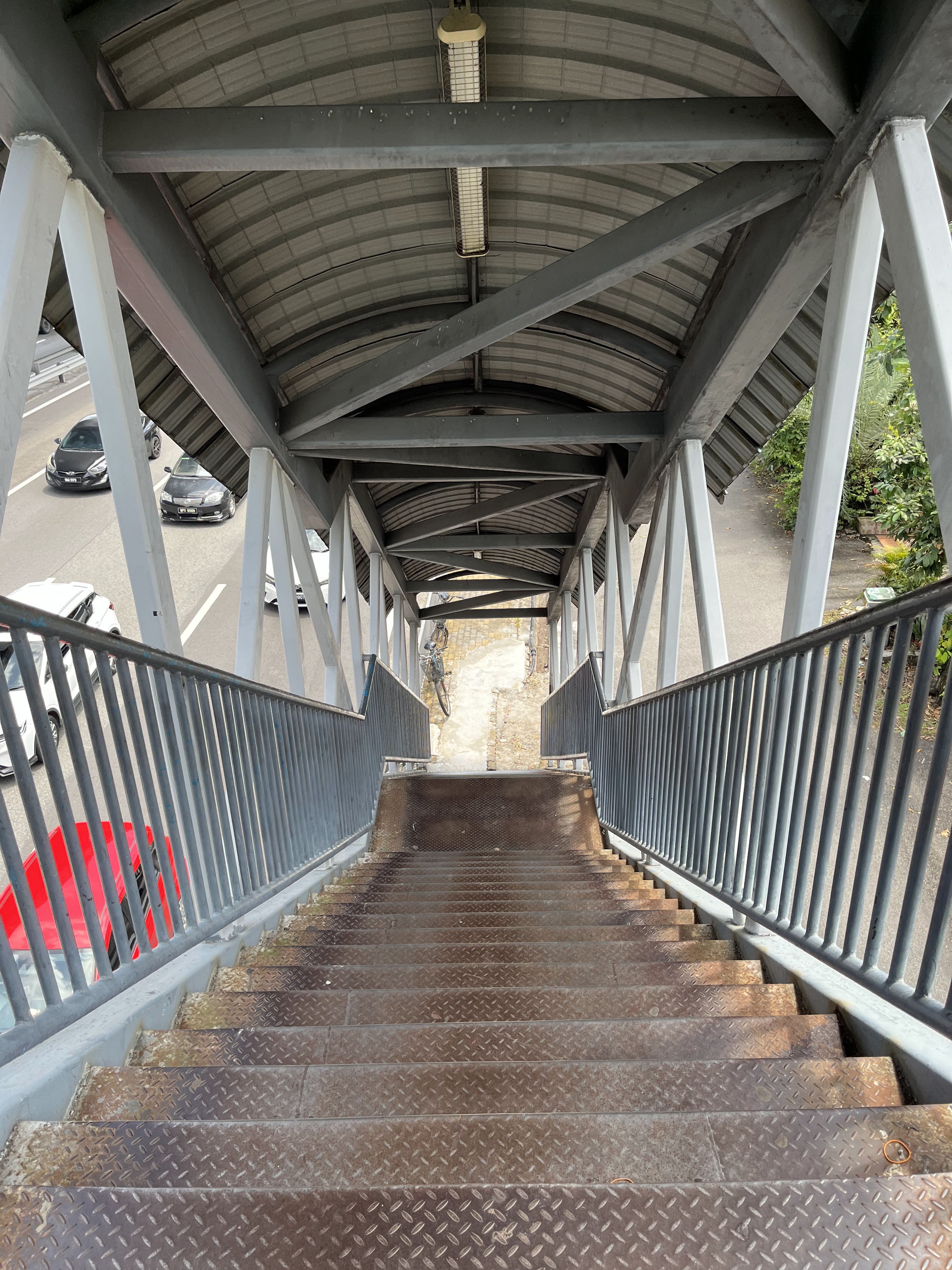
The station currently doesn't even have ramps or lifts - accessibility is very poor. To enter from the east side requires hiking over one pedestrian bridge, going through the barriers, then crossing over another pedestrian bridge to get back to the east side platform (ridiculous).
Angkasapuri station sandwiched up against the New Pantai Expressway
To
maximise the potential of our public transport systems they must be
made convenient. This means accessing them WITHOUT A CAR. That means having car-free access routes (something that seems to be anathema to Malaysian planners). The map below shows more closely how this could be achieved. Additionally, permissive pathways through Angkasapuri could be a quick and effective solution to boost connectivity to the west of the station.

Zoomed in proposal for pedestrian crossing of the Klang River connecting
into Angkasapuri station and beyond (new bridge in red colour). (North direction upwards.)
Funding
People may ask where would the money come from for these kinds of improvements. The first thing to remember is that pedestrian bridges, paths and covered walkways are relatively cheap. So it's not a lot of money.
The KTM line itself is already there (and has been since before Malaysia was a country) and the Klang Valley Double Tracking project is underway (albeit painfully slowly - but that's another story). As that project progresses, new funding should be made available to enhance the accessibility of KTM stations - lifts, fare gates on both sides of the station, information systems, signage, and general maintenance. Also not that expensive compared to car infra.
Just look around and you will see so much car infrastructure in Malaysia - very very heavy and expensive. Old Klang Road has been widened, barriers installed, car ramps tying in at various locations. Again, this is expensive infra, costly to build and maintain. So it's a question of priorities. Car infra has been massively prioritised, with very high costs, over cheaper car-free infra.
This prioritisation is happening right now in 2025 at this location. The new condo projects next to the KTM station will have car ramps binding them to surrounding highways. In articles about the project, the developer boasts of 'investing' in connectivity:
"A RM25 million infrastructure investment is currently underway to
construct an exclusive road link to the Federal Highway and the New
Pantai Expressway (NPE), scheduled to be completed in tandem with River
Park"
How much has been 'invested' in the pedestrian walkway? And how much would a pedestrian bridge over the Klang River cost? Less than RM25m, for sure. These kinds of huge condo projects have significant impacts on the areas around them and there is very little being done by developers or local authorities (e.g. DBKL) to make sure sensible supporting infrastructure is implemented alongside them.
Condo plans show the new 'link bridge' that is being built (see columns under construction). It's for cars.
Foundations being constructed alongside the Klang River apposite Vivo. Could this be for a pedestrian bridge? No. It's 2025, it's Malaysia, and that means more car ramps for condos with dizzying amounts of parking.
The pathways along the Klang River (aka extension of River of Life) may have their own funding source following the work that Klang River Festival and KongsiKL have been doing (can that channel some DBKL funding too?). The new pedestrian bridge to the KTM station could be funded by a Railway Asset Core accessibility improvement fund, and/ or by the adjacent condos that are under development, along with DBKL.
It's 2025 and the best option local residents have of crossing the river is to walk on the highway bridge.
A livable future?
The good thing is it's not too late - installing a pedestrian bridge over the Klang is absolutely possible as is implementing a network of pedestrian/ cycling paths with some canopies. In time, some of the road space can be easily converted into other uses - small linear parks, trees for shade, pathways, perhaps some space for warungs, cycle lanes, and at-grade pedestrian crossings. The river corridor can be an active travel artery doubling up as a recreational space and refuge against the concrete jungle.
In time, dedicated bus lanes should be extended along many major roads. Even better, for Old Klang Road, build an at-grade tram line. Reconfigure this choked stroad into something suitable for a productive, efficient artery in a livable city. Give Old Klang Road a new lease of life and unlock the potential of KL's railways and rivers.
A glimpse at Old Klang Road's future?


