Railways and condos with so much potential
This station on the KTM line (Port Klang - Tanjung Malim) is next to Kampung Medan and a busy industrial area of PJ. It is also opposite a school.
The population residing near the station is large and growing (as would be expected in an urban area like PJ) and there are also many workers commuting daily to workplaces nearby the station.
The KTM line has a theoretical maximum capacity in the range 30,000 - 50,000 passengers per hour and is routed along a corridor of dense population centres including important destinations like KL Sentral.
There are existing high rise apartments in the area, some more have recently been built, and there are more coming too. See below for a summary of apartments / condos within 1km.
| Apartment name | Number of units / floors | Distance to nearest KTM station |
|---|---|---|
| Dwitara Residences | 1756 / 43 | 980m |
| Residensi NewUrban | 922 / 36 | 790m |
| Villaria Kondominium | 304 / 19 | 730m |
| Verando Residence | 1055 / 35 | 550m |
| Apartment Desa Mentari 3 | 6239 / 18 | 870m |
| Aparment Desa Mentari 2 | ~3000 / 18 | 390m |
| Taman Medan Cahaya (8 blocks) | ~1000 / 17 | 280m |
| TOTAL UNITS | 14,276++ |
Marked on a map:

So, what is the population of this area now? What will it be in a decade? It will surely be a big number.
Yet, the ridership at this station is SO LOW. Even at peak times it doesn't get that many users.
If it's so close to all these things, why is hardly anyone using it? Leaving aside the car-centric mindset of many Malaysians, there are two key problems: extremely poor service from the KTM, and horrific accessibility into and around the station.
An Access Nightmare
The station has been trapped against a giant toll plaza (completed in 2004, toll abolished for KL-bound traffic in 2009) for the NPE highway. Predictably there is no convenient pedestrian route from the other side of the highway, so it needs to be accessed via poor quality and poorly maintained pedestrian bridges with steep stairs.


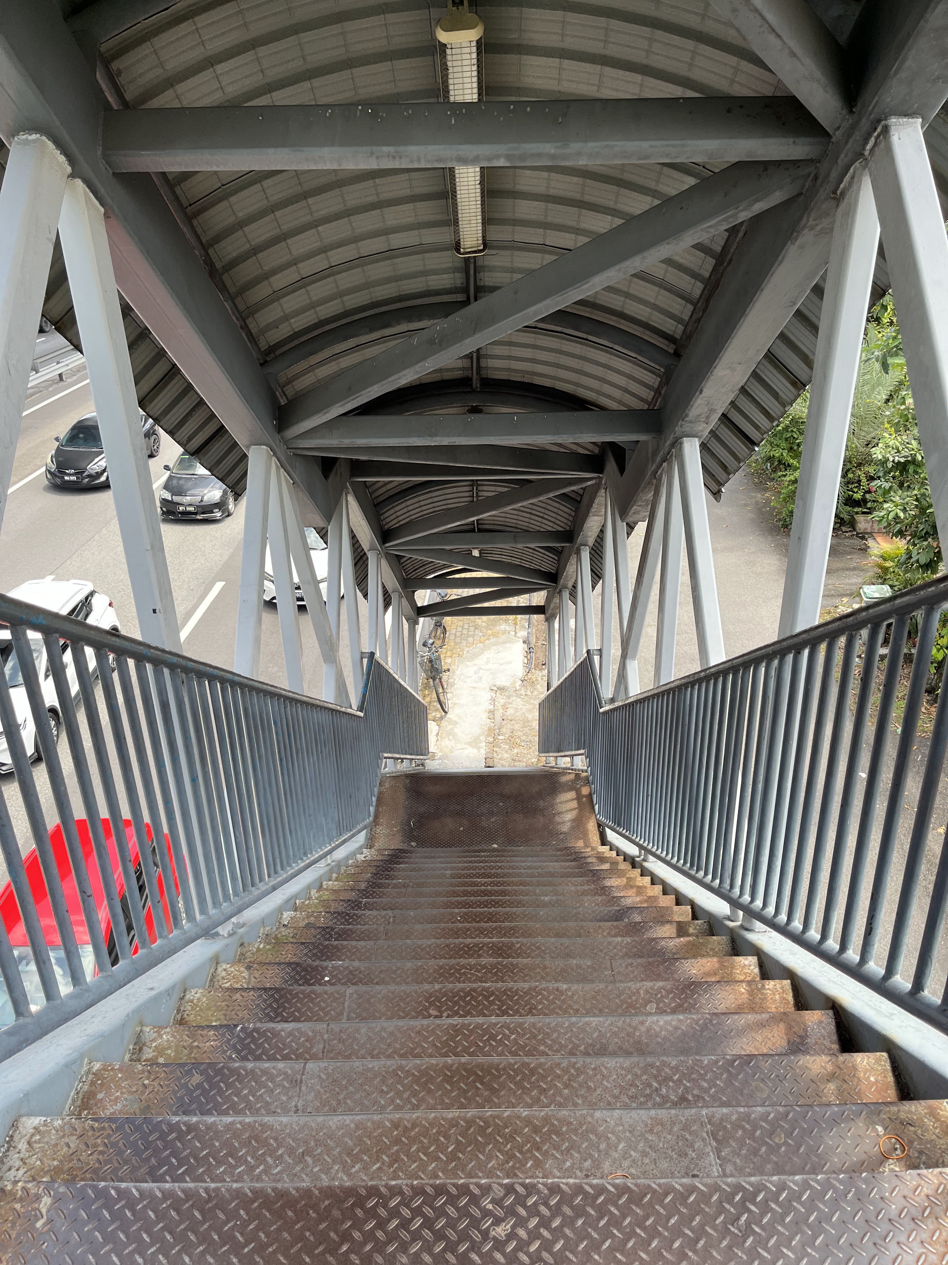

This route is the only pedestrian access across the highway in this area so it does get daily users just wishing to cross the highway. Is this really the best Petaling Jaya can offer them?
Is it any wonder that residents in this area want something to be built - anything - even PJD Link - if this is what they have to put up with now?
Putting the Kampung in Kg Dato Harun


One of the residents of Kg Dato Harun striking a pose.

North entrance to Kampung Dato Harun station. Is it time to quit driving and go cold turkey?
This is incredible neglectful to the area, which is full of factories with many workers who don't drive. The streets in the area are actually quite reasonable - with trees for shade, wide verges for walking and relatively low speed traffic.


Simple Improvements
- On the north side, request the workshop businesses to keep a safe walking route clear at all times.
- Widen the walking paths, fix uneven and broken tiles and handrails, provide canopies and lighting.
- Keep the farm animals out of the path.
- Fix the steps at the end points of the pathways.
- For the south side (Kg Medan), fix up the bridges, provide lighting and signposts. Put some bicycle and scooter parking at the foot of the bridge.
With a bit more budget, lifts and ramps could be included to make it accessible for OKU.
Sustainable Solutions
However all these half-measures are not really good enough and a transformation is called for. Imagine what you could do with a tiny fraction of the budget of PJD Link:
- Roll out micromobility hubs (Beam Scooters, bikes docks/ parking)
- Study and implement a network of good quality connecting paths over a wider area
- Provide a bus drop off point from the north side
- Upgrade station facilities with lifts
- Add separate bridges or a wide deck for cycle, scooter and pedestrian access direct to the station and also directly across the highway. Open up the access routes and reduce car-dependency.
- Take back the useless toll plaza, which is mainly serving a tiny group of wealthy highway concessionaires. Turn it into a tree-lined public park to shield the neighbourhood from the highway. (NB. The way tolls are collected might be changing which will potentially free up space at toll plazas.)
- Provide connecting routes to Seri Setia station as an alternative.

PJD Link Demands
While access to public transport is this poor, people will be tempted to reach for the idea of adding something new (especially highways) - something that they think might help with the situation they currently have to put up with.
In this case the PJD Link is not in the same direction as the KTM line, but opening up more connectivity across the divisive NPE highway will help give people more options. The current situation is an example of how poor connectivity and accessibility begets more highways in a vicious, unstoppable cycle.
The Density Question
This case study shows that density is not a solution in itself. Being high density doesn't somehow automatically save developments and make them good. Density done badly is still bad. High density needs to be paired with good planning and transport accessibility. Imagine if Hong Kong or Tokyo were just giant condos on top of giant parking towers surrounded by mega highways. It would be a disaster.
Let's bring some nuance to the planning discussion so that when we do high-density we do it well.
A Little Bit of History
For those interested in the history of the line and area, see below this rail map showing the old names of the stations.

Also there is some recent history with the toll plaza at PJS2 - there were actually protests by disgruntled residents. Sadly, they weren't protesting that the toll plaza was blocking their access to the KTM station. They were protesting that they had to pay the toll. On the grounds that there was no alternative to get to KL... The toll was duly abolished in 2009.


No comments:
Post a Comment